
Political boundaries are invisible or visible lines that define the geographic limits of political entities such as states, nations, or municipalities. These lines separate the authority of one government from another and are foundational to modern political geography.
What Are Political Boundaries?
Political boundaries are critical tools used by states and governments to demarcate the areas over which they exert power and authority. These boundaries define the scope of governance, law enforcement, resource management, and territorial sovereignty. Whether drawn through international treaties or unilaterally imposed, political boundaries influence a wide array of issues including citizenship, trade, cultural identity, and conflict.
Sovereignty: Political boundaries mark where one state's sovereignty ends and another’s begins. Sovereignty refers to the recognized authority a state has to govern itself without external interference.
Jurisdiction: Boundaries determine the legal authority of governments over specific geographic areas. This includes laws, taxation, policing, and the justice system.
Potential for Conflict: Disputes over political boundaries are a major source of international and domestic tension. Conflicts can arise from colonial legacies, contested ethnic territories, or access to valuable resources.
Boundaries are not static—they evolve due to war, colonization, decolonization, international negotiation, and internal secessionist movements. As such, they remain dynamic and central to geopolitical understanding.
Forms of Political Boundaries
Political boundaries can be identified in several ways based on how they are created and represented.
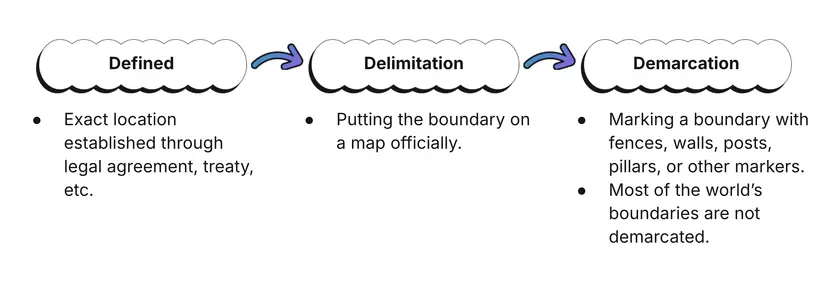
Defined Boundaries
A defined boundary is one that is formally and legally described in documents such as treaties, constitutions, or agreements. These documents may specify geographic coordinates, natural features, or descriptions that clearly articulate where the boundary lies.
Example: The Treaty of Tordesillas (1494) established a defined meridian dividing the New World between Spain and Portugal.
Defined boundaries provide the basis for international law and diplomatic recognition.
Delimited Boundaries
Delimited boundaries are those drawn on maps to visually show the limits of a state or political unit. Delimitation is a crucial process in cartography and is often the result of legal definitions.
These lines do not physically exist on the ground but serve as official records for reference.
Example: The border between Egypt and Libya appears as a straight line on most maps, having been delimited based on colonial agreements.
Demarcated Boundaries
Demarcated boundaries are physically marked on the landscape with objects such as walls, fences, signs, or posts. These markings reinforce the visual and practical presence of the boundary.
Example: The border fence between India and Pakistan is an extensive demarcated boundary that includes floodlights and patrol towers.
Demarcation adds enforcement and permanence to a boundary that may already be defined and delimited.
Classification by Physical and Human Criteria
Political boundaries can follow either physical features of the landscape or artificial constructs based on human decisions.
Natural Boundaries
Natural boundaries align with prominent physical features like rivers, mountains, deserts, and oceans. These boundaries are usually easy to recognize and often predate human settlement.
Rio Grande: Serves as a natural boundary between the United States and Mexico, often cited in discussions of immigration and border policy.
Himalayas: Act as a massive natural barrier separating countries such as India, China, and Nepal. They are nearly impassable in some regions and thus form strong physical boundaries.
Sahara Desert: Divides North African nations and is a challenging natural barrier to political and cultural integration.
Natural boundaries can provide defensive advantages and create long-lasting separations between cultural or political groups.
Geometric Boundaries
Geometric boundaries are straight lines often based on latitude or longitude. These do not reflect physical or cultural features and are typically a result of political agreements or colonial impositions.
U.S.-Canada border: A well-known example of a geometric boundary along the 49th parallel north.
Egypt-Sudan border: Another example where geometric reasoning overrides cultural or natural demarcations.
These boundaries can appear arbitrary and sometimes lead to complications when they divide cohesive cultural or ethnic groups.
Cultural Boundaries
Cultural boundaries reflect differences in language, religion, ethnicity, or customs between people on either side of the line. These boundaries are more fluid and subjective.
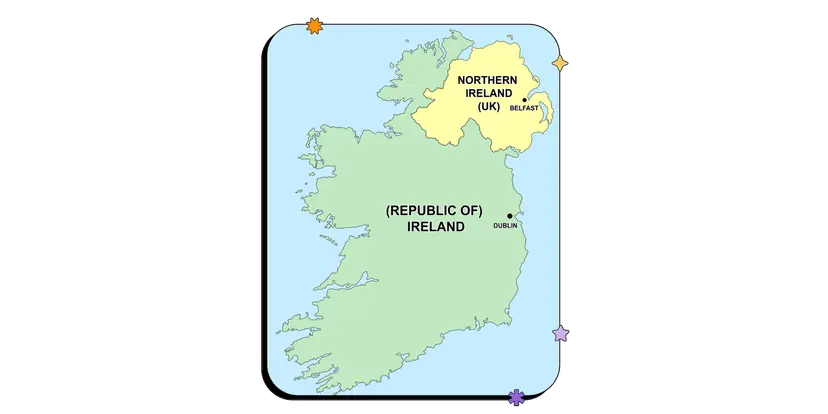
Northern Ireland and the Republic of Ireland: Divided by religious identity—Protestant vs. Catholic—which underpinned decades of conflict.
Catalonia in Spain: Seeks autonomy based on its distinct language and cultural traditions.
Israeli-Palestinian conflict: A deep cultural and religious divide that defies easy geographic resolution.
Because cultural traits are not confined to specific spaces, cultural boundaries can shift over time, creating zones of dispute or blending.
Economic Boundaries
Economic boundaries are drawn based on differences in economic development, trade relationships, and access to resources.
Trade Zones: Agreements like NAFTA and the EU have reduced economic boundaries, promoting free movement and shared markets.
Economic Sanctions: Countries may impose trade restrictions on others, effectively creating economic boundaries that isolate or control access.
Resource-Based Divisions: Disputes over oil, gas, and mineral deposits often create economic boundaries between countries or regions.
Economic boundaries are more dynamic and tend to fluctuate with policy changes, market conditions, and global economic integration.
Classification by Time of Establishment
When a boundary was created plays a critical role in its stability and relevance.
Antecedent Boundaries
Antecedent boundaries are drawn before a large population occupies an area. They may coincide with natural features or be imposed based on early exploration or colonial interests.
U.S.-Canada boundary: Set before the western territories were heavily populated.
Andes Mountains boundary between Chile and Argentina: Based on natural topography established before population growth.
Antecedent boundaries can be more stable because newer settlements adapt to them rather than resist them.
Subsequent (Ethnographic) Boundaries
These are established after a region has been significantly populated and developed, often reflecting cultural, ethnic, or linguistic divisions.
Ireland/Northern Ireland: A classic example of a boundary drawn after religious divisions emerged.
Balkan Peninsula: Post-Yugoslav states were divided along ethnographic lines, leading to new political boundaries.
These boundaries are often contentious if the divisions they reflect are recent or ongoing.
Source: Wikipedia
Consequent Boundaries
Consequent boundaries are a type of subsequent boundary drawn to reflect a particular cultural characteristic.
India and Pakistan: Partitioned by religion, dividing Muslims in Pakistan from Hindus in India.
Utah: The cultural influence of Mormonism shapes local laws and social norms, distinguishing it within the United States.
These boundaries aim to reduce conflict by aligning political units with cultural identities but can also reinforce divisions.
Superimposed Boundaries
Superimposed boundaries are imposed by external powers without regard for existing social, cultural, or ethnic landscapes.
Africa’s colonial borders: European powers drew boundaries during the Scramble for Africa, splitting tribes and ethnic groups across multiple states.
Native American territories: Overridden by U.S. state boundaries during westward expansion.
Superimposed boundaries often result in long-term instability and conflict.
Relic Boundaries
Relic boundaries are no longer in use but have left a visible imprint on the landscape or society.
Berlin Wall: Though demolished, its path is marked throughout Berlin with bricks and plaques.
Great Wall of China: A relic from ancient Chinese territorial defense, still standing as a monument and tourist attraction.
These boundaries shape cultural memory and historical identity even if they no longer serve a functional political role.
Militarized Boundaries
Militarized boundaries are fortified with military presence, often restricting movement and serving as zones of tension.
Korean DMZ: A highly guarded strip separating North and South Korea, symbolizing Cold War hostilities.
India-Pakistan border: Especially volatile near the Line of Control in Kashmir.
U.S.-Mexico border: Includes physical barriers, surveillance, and patrol forces to manage immigration and smuggling.
Militarized boundaries are signs of strained political relations and often sites of human rights issues or armed conflict.
Open Boundaries
Open boundaries allow for the unimpeded movement of people, goods, and services. These are usually seen in regions with political and economic integration.
European Union: Schengen Area permits passport-free travel among member states.
Example: A person can live in France, work in Germany, and send their children to school in Luxembourg.
Open boundaries encourage unity and cooperation but may face challenges related to migration policy and national security.
How Boundaries Are Established
Treaties and Negotiations
The majority of modern political boundaries are the result of formal agreements between states. These treaties are recognized by international organizations such as the United Nations.
Example: The 1818 agreement between the U.S. and Britain establishing the 49th parallel.
Wars and Conflict Resolutions
Post-conflict treaties often result in boundary changes or new state formations.
Post-WWII Europe: Led to the redrawing of borders, including the division of Germany.
Partition of India: Resulted in the creation of Pakistan and later Bangladesh.
Colonial Decisions
Colonial boundaries often ignored indigenous or ethnic realities, leading to future strife.
Example: The Berlin Conference of 1884–85 where European powers divided Africa with no African input.
Modern Diplomacy and Arbitration
In today’s international system, boundaries are sometimes created or refined through peaceful arbitration, using tools such as satellite imagery, census data, and international courts.
Example: The Eritrea-Ethiopia Boundary Commission’s decision in the early 2000s.
Political boundaries remain among the most significant tools for organizing human space. Understanding their forms, origins, and consequences is essential for comprehending global politics and geography.
FAQ
Political boundaries can persist for several reasons, even when they no longer align with current cultural, ethnic, or social realities:
Legal and diplomatic recognition: Boundaries are often recognized by international law and institutions like the United Nations. Changing them would require renegotiation or conflict resolution, which is often complex.
Political stability: Even if boundaries no longer reflect the population’s composition, altering them can trigger instability or unrest.
Infrastructure and governance: Governments may have invested in infrastructure, services, and administrative systems based on current boundaries, making them difficult to change.
Historical inertia: Populations may have adapted to long-standing boundaries, making them culturally accepted despite initial divisions.
Fear of conflict: Redrawing boundaries might reignite ethnic or political tensions. Many governments avoid this to maintain peace.
In short, historical precedent, legal frameworks, and practical concerns often outweigh the benefits of redrawing outdated political boundaries.
Political boundaries often marginalize indigenous populations by disrupting traditional territories and limiting access to resources or political representation. These impacts are particularly evident in settler-colonial countries like the United States, Canada, and Australia.
Forced displacement: Many indigenous communities were relocated when state boundaries or policies did not recognize traditional land use.
Jurisdictional disputes: Indigenous governance systems may conflict with federal or state laws, especially on issues like law enforcement, taxation, and land rights.
Limited autonomy: While some tribal lands have recognized sovereignty, it is usually limited and subject to national law.
Resource access: Boundaries can cut through ecosystems or sacred lands, restricting hunting, fishing, or cultural practices.
Overall, state-imposed political boundaries often override preexisting indigenous territories, causing long-lasting socio-political and economic challenges for native groups.
Boundary disputes can arise from disagreements about the location, function, or legitimacy of a political boundary. These disputes are classified into four major types:
Definitional disputes: Conflict over the legal language describing a boundary. Example: Chile and Argentina’s disagreement over vague 19th-century treaty terms.
Locational disputes: Disagreements over the actual placement of a boundary on the ground.
Operational disputes: Focus on how a boundary should function, like regulating immigration or customs policies.
Allocational disputes: Involve natural resources like oil or water that cross boundaries.
Resolutions include:
Bilateral negotiations or mediation.
International courts or arbitration (e.g., International Court of Justice).
Use of satellite imagery and cartographic evidence for accurate delimitation.
Most disputes are peaceful but can escalate to conflict if not addressed diplomatically.
Buffer states and frontier zones are important geopolitical features that influence how and why boundaries are drawn.
Buffer states: These are smaller or weaker countries located between two more powerful states, serving to prevent direct conflict. Example: Mongolia between China and Russia during the Cold War.
Help reduce friction by physically separating rival powers.
Often neutral in foreign policy to maintain balance.
Frontier zones: Unlike clearly defined boundaries, frontiers are wide, ungoverned, or sparsely populated areas.
Historically used to mark limits of state control (e.g., the American West in the 1800s).
May eventually solidify into fixed boundaries as state control expands.
These areas serve as transitional spaces where boundary negotiations, expansion, or conflict often occur, making them crucial to understanding state formation and boundary evolution.
Modern technology plays a significant role in both the creation and enforcement of political boundaries, improving accuracy and management.
GIS (Geographic Information Systems): Helps map and analyze spatial data, making boundary delimitation more precise and based on updated geographic and demographic information.
Satellite imagery: Used for surveillance, resource monitoring, and dispute resolution. Countries can track unauthorized border crossings or environmental changes.
Drones and sensors: Improve border security, especially in remote or militarized zones, by monitoring movement and detecting breaches.
Digital databases: Store legal documents, maps, and demographic data, making it easier for governments to manage and communicate border-related policies.
AI and predictive modeling: Assist in analyzing population movement or environmental threats that could impact boundary relevance or enforcement.
Practice Questions
Explain the difference between geometric boundaries and cultural boundaries, and provide a real-world example of each.
Geometric boundaries are straight lines or arcs often based on latitude or longitude and are drawn without regard to physical or cultural landscapes. An example is the 49th parallel separating the United States and Canada. Cultural boundaries, on the other hand, are based on human traits like language, religion, or ethnicity. These are more fluid and reflect the identity of people within the space. An example is the boundary between Northern Ireland and the Republic of Ireland, which reflects religious and cultural divisions between Protestant and Catholic communities and has historically been a source of conflict.
Identify and describe one type of political boundary established before settlement and one established after significant human development. Use specific examples.
An antecedent boundary is drawn before a large population settles in an area, often aligning with natural features. For instance, the boundary between the U.S. and Canada along the 49th parallel was established before westward expansion and development occurred. A subsequent (ethnographic) boundary is created after significant settlement, reflecting cultural or social divisions. The boundary between Northern Ireland and the Republic of Ireland is a clear example, drawn long after population growth and based on religious divisions. These types of boundaries reflect different historical and cultural contexts in which political spaces are shaped and contested.
