
Settlement patterns and land survey methods provide geographers with insight into how rural areas are structured, how communities use the land, and how landscapes are shaped by cultural and historical forces.
Understanding Land-Use Patterns
Land-use patterns refer to how land is organized and utilized in a given area. This includes the spatial distribution of residential, agricultural, commercial, and industrial uses across a landscape. In rural contexts, land-use patterns are primarily associated with agriculture, resource extraction, and the physical arrangement of homes and infrastructure.
These patterns are not random—they reflect centuries of environmental adaptation, economic needs, political decisions, and cultural traditions. The way land is divided, owned, and occupied affects access to resources, efficiency of services, social relationships, and environmental sustainability.
Factors Influencing Land-Use and Settlement Patterns
Economic Forces and Market Demand
Market demand plays a powerful role in shaping land use. When population growth increases demand for housing or food, agricultural lands may be converted into residential or commercial spaces. Similarly, farmers may prioritize high-demand, high-profit crops over traditional subsistence farming.
Areas near cities may grow vegetables or flowers for urban markets.
Distant rural areas may produce bulk commodities like wheat or soybeans.
Land closer to infrastructure tends to be more intensively used.
High demand encourages clustered settlements and intensive land use, while lower demand may result in more dispersed land-use patterns.
Natural Resources and Physical Geography
Access to natural resources—including water, fertile soil, forests, and minerals—has historically determined where people settle and what land is used for.
Fertile river valleys encourage dense settlements and intensive agriculture.
Arid or mountainous areas are more likely to support dispersed pastoralism.
Forests and mineral-rich regions may lead to extraction-based economies.
The topography, drainage patterns, and soil types all shape the sustainability and productivity of the land, influencing whether settlements are clustered for shared access or dispersed to exploit scattered resources.
Transportation Infrastructure
Access to transportation is a central factor in rural settlement patterns. Transportation corridors like roads, rivers, and railways facilitate trade, communication, and service delivery.
Settlements often develop in linear patterns along transportation routes.
Villages situated at crossroads or ports tend to become clustered.
Areas far from transportation may have dispersed settlements due to isolation.
The presence or absence of reliable transport can determine whether an area remains rural and low-density or evolves into a commercial agricultural hub.
Government Policies and Land Management
Governments shape rural land use through legislation, regulation, and planning.
Zoning laws determine what activities are allowed on different parcels of land.
Subsidies and tax incentives encourage specific land uses like conservation or biofuel production.
Land reform can redistribute land ownership, transforming settlement and productivity patterns.
For example, the U.S. Homestead Act encouraged dispersed settlements on 160-acre plots, while French colonial policies favored linear settlements with equal river access.
Environmental Constraints
Environmental factors such as climate, natural hazards, and landscape features directly impact land usability.
Flood-prone areas discourage dense settlements but may support rich agriculture.
Steep slopes limit mechanized farming and favor dispersed hillside communities.
Earthquake zones, drought areas, and volcanic regions influence long-term settlement viability.
The need to adapt to environmental risks often explains regional variation in land use and settlement types.
Types of Rural Settlement Patterns
Clustered (Nucleated) Settlements
In clustered settlements, buildings are grouped together, forming a dense residential and community area surrounded by agricultural land. This pattern is common in traditional farming villages and often reflects social cooperation, shared defense, or access to water and communal services.
Key Features:
Houses built close together in a central node
Fields arranged around the community
Shared infrastructure like schools, religious buildings, and markets
Advantages:
Efficient delivery of services and infrastructure
Strong community ties and social interaction
Compact land use allows for preservation of farmland
Disadvantages:
Can lead to congestion and overuse of shared resources
May limit land for new housing or farming as population grows
Examples: Found widely in parts of Europe, South Asia, and sub-Saharan Africa, where agricultural land surrounds a core village.
Dispersed Settlements
Dispersed settlements are characterized by individual homes and farms spread across large rural areas. This pattern is typical where land is abundant, and families value independence or land ownership.
Key Features:
Homes spaced widely apart, often on separate plots
Each household tends its own fields and may be self-sufficient
Little to no centralized infrastructure
Advantages:
Greater privacy and land ownership
Less crowding and localized environmental pressure
Encourages diverse land use and farming practices
Disadvantages:
Harder and more expensive to provide public services (schools, roads, healthcare)
Less social cohesion or communal identity
Longer travel times for goods and services
Examples: Common in the U.S. Midwest, rural Canada, and parts of Australia.
Linear Settlements
Linear settlements develop along transportation corridors like rivers, roads, or railways. The linear shape reflects the importance of access to transportation and trade.
Key Features:
Buildings and homes aligned along a straight line
Agriculture often located behind residences
Infrastructure like power lines and roads also follow the linear path
Advantages:
Good access to transportation and communication
Encourages trade and efficient travel
Compact enough to allow for some shared infrastructure
Disadvantages:
Expansion limited to narrow corridors
Environmental impact along the entire line
Infrastructure must stretch across long distances
Examples: Found in Quebec along the St. Lawrence River, parts of rural England, and former French colonies.
Importance of Settlement Patterns
Service Provision
The type of settlement pattern impacts how easily services like electricity, education, and sanitation can be delivered. Clustered settlements are more efficient to serve, while dispersed settlements require more infrastructure per capita.
Economic Viability
Access to markets and the scale of operations differ with settlement type:
Clustered settlements may support cooperatives or shared processing centers.
Dispersed settlements may focus on large-scale monoculture or ranching.
Environmental Impact
The ecological footprint of settlements varies:
Clustered patterns can lead to localized degradation but preserve open space.
Dispersed settlements spread impact but may consume more total land.
Cultural Identity
Settlement patterns reflect and reinforce cultural traditions:
Some societies prioritize communal life and cooperation (clustered).
Others value privacy, autonomy, or land inheritance practices (dispersed).
Survey Methods in Rural Land Division
Survey systems define how land is divided and influence long-term land-use patterns. These systems often reflect colonial history, governmental goals, or environmental adaptation.
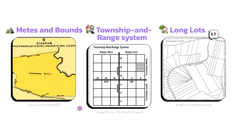
Long Lot System
The long lot system was developed in French colonial regions and allocates narrow plots that extend from a central resource like a river, road, or canal.
Key Features:
Narrow frontages with long, deep lots
Equal access to key resources (water, roads)
Often found along rivers or other linear features
Benefits:
Ensures fairness in resource access
Supports linear settlement and efficient transportation
Limitations:
Can become inefficient as technology changes or land needs expand
Examples: Quebec (Canada), Louisiana (USA), and Vietnam.
Metes and Bounds System
This method uses natural landmarks, compass directions, and distances to define land parcels. It’s flexible and reflects local terrain, but less standardized.
Key Features:
Metes: measured boundaries (e.g., “200 feet north”)
Bounds: general features like trees, rivers, or roads
Irregular shapes and sizes of land parcels
Benefits:
Adapts to varied geography
Supports historical claims and local practices
Limitations:
Difficult to standardize
Disputes arise when landmarks change or disappear
Examples: Found in the original 13 U.S. colonies, particularly in New England and the South.
Township and Range System
Developed under the Land Ordinance of 1785, this grid-based system divides land into square units. It was designed to simplify sale, taxation, and governance in newly acquired western U.S. territories.
Key Features:
Land divided into townships (6 miles x 6 miles)
Each township contains 36 sections (1 mile x 1 mile)
Uniform parcel shapes and sizes
Benefits:
Highly standardized and easy to survey
Facilitates infrastructure and property ownership
Limitations:
Ignores terrain, water bodies, and indigenous claims
Not suited to varied landscapes
Examples: Most commonly found in the central and western United States.
Comparing Settlement Patterns and Survey Methods
Survey methods and settlement patterns are interconnected. The way land is divided influences how people live, how communities grow, and how infrastructure is built.
Long lot systems often lead to linear settlements because each family builds along the shared resource (river or road).
Township and range promotes dispersed settlements, as each plot is evenly sized and spread out.
Metes and bounds support a mix of dispersed and clustered patterns depending on geography and culture.
FAQ
Traditional survey methods like metes and bounds persist in certain regions due to historical land ownership patterns and legal frameworks that continue to recognize them. These methods are deeply rooted in the early settlement and development of eastern parts of the United States, especially where land was divided before the adoption of the township and range system.
Many older land titles and deeds still describe boundaries using natural landmarks and metes and bounds terminology.
Modernizing these descriptions would require costly legal and surveying efforts, often unnecessary if land use has remained consistent.
In rural or less developed areas where land parcels are irregular and follow natural features like rivers or ridges, metes and bounds remains more practical than grid-based systems.
Courts and land records offices in these regions are accustomed to interpreting these descriptions, maintaining institutional continuity.
Topography plays a critical role in determining the most efficient and sustainable rural settlement pattern in a region. The physical layout of the land impacts accessibility, resource availability, and construction feasibility.
In mountainous or hilly terrain, dispersed settlements are common because flat land suitable for agriculture is scattered and homes are built wherever land is usable.
In flat, fertile plains, clustered or linear settlements may be easier to develop because there are fewer natural barriers.
River valleys often foster linear settlements where the population builds along the water source for access to irrigation, transportation, and fertile land.
Steep terrain may also prevent roads and utilities from reaching distant homes, discouraging dispersed patterns.
Rural settlement patterns shaped the social and economic landscape of early American agriculture by dictating how communities were formed and how land was utilized.
The long lot system, introduced by French colonists, allowed each settler access to water routes, supporting transportation and irrigation for crops.
The township and range system, developed by the U.S. government after the Land Ordinance of 1785, promoted equitable land distribution and efficient development in the Midwest and West.
Clustered settlements encouraged the formation of communal agriculture and shared infrastructure like mills and churches.
Dispersed farms in the South fostered plantation economies, where large estates operated independently and depended on slave labor.
These patterns influenced economic specialization, community development, and regional identities that persist today.
Cultural traditions significantly influence settlement patterns by shaping how communities organize themselves socially and spatially. The norms, values, and land ownership practices of a society often dictate the preferred way to build and live.
In societies that emphasize communal living and cooperation, clustered settlements are common. Families live near each other to share responsibilities and maintain close social ties.
Cultures that value independence and land ownership often favor dispersed settlements, where individuals manage their own land and resources.
Some religious or ethnic communities, such as the Amish, maintain distinct clustered settlements to preserve cultural practices and mutual support systems.
Indigenous populations may establish linear settlements along rivers or coastlines to sustain fishing or transportation traditions.
Tradition often overrides geography or modern planning, especially in tightly-knit rural communities.
Modern infrastructure developments can alter or disrupt traditional rural settlement patterns by changing how land is accessed, used, or valued.
The construction of highways, railways, or large dams can divide previously cohesive clustered or linear settlements, forcing relocation or redevelopment.
Improved transportation networks may lead to a transition from dispersed to more clustered patterns, as accessibility to services increases and commuting becomes feasible.
Infrastructure can attract population growth in previously isolated areas, encouraging nucleated development and suburban expansion.
Conversely, some areas experience depopulation due to industrial farming or economic shifts, leading to abandoned dispersed settlements.
Practice Questions
Compare the township and range survey system to the long lot system. Explain how each influences rural settlement patterns.
The township and range system divides land into uniform, grid-like parcels, promoting dispersed settlement patterns as farms and homes are spread evenly across large areas. This system, common in the western United States, simplifies land ownership and infrastructure development but does not follow natural features. In contrast, the long lot system divides land into narrow strips extending from a central resource like a river or road, encouraging linear settlements. Each lot has equal access to water or transportation, fostering community clustering along the feature. These systems reflect differing priorities in land use, access, and community interaction.
Explain how environmental factors influence the development of clustered, dispersed, and linear rural settlement patterns.
Environmental factors shape rural settlement patterns by influencing access to resources, land suitability, and transportation. Clustered settlements often develop in fertile valleys or near water sources, where shared access to resources like irrigation is essential. Dispersed settlements emerge in areas with abundant land, such as plains or dry regions, where families live independently to manage large tracts of farmland. Linear settlements typically form along rivers, roads, or coastlines, where environmental features dictate the arrangement of homes and farms in a line. Each pattern adapts to the landscape’s opportunities and limitations, reflecting the relationship between environment and human activity.
